
3D Mapping - Site Analysis
1. Site Visit
A member of our team will schedule an appointment to come out to your property to have a site visit with you. At this stage the direction of the project will be discussed. The overall goals of the project will be defined at this stage.
2. Site Analysis
Measurements will be taken of your property. Depending on the scope of work necessary these measurements will then be transferred to a blueprint drawing where they will be ready to start creating your landscape design.
New for 2025 we have implemented a measuring software that allows us to turn your site into a 3D terrain model. This gives us all the necessary information to alter topography on site in real time, including accurate cut and fill projections. This service is especially important for water related issues or any aspect of land alteration.
3. Preliminary Design
Once a blueprint has been created we are ready to move to the design phase. At this stage a number of ideas previously discussed with the client are put on paper. The fundamentals of the design are created such as walkways, structures, gathering areas, etc. Any major changes to the design are completed at this phase. The majority of the design is finalized at this phase.
4. Final Design
The finishing touches are in the details! The finalized design will have all elements that were discussed in the initial site visit. Details such as planting design, any construction drawings related to the project, measurements, etc. This design is presented to the client where they can choose to move forward into the building phase if they prefer.
5. Cost Estimate
We work closely with our clients to ensure the design is built to the highest standard and within their budget. At this phase we will discuss all the costs associated with building your project. HUTCON can be hired as project managers to oversee your project, or contractors to build your project.
6. Build
We are committed to building sustainable and energy-efficient landscapes that are environmentally friendly. Let our team install your project today!
3D site mapping service
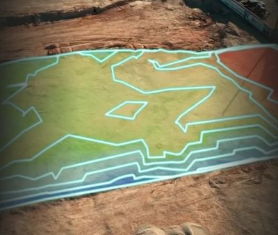
Site Topography Mapping
Residential Construction
Residential Construction

Measuring multiple points within your site allows us to create an accurate 3D picture of your yard including the high and low topographical areas. This gives us the accurate information required for removing or bringing in fill or aggregate.
Residential Construction
Residential Construction
Residential Construction
Pictured above is a 3D example of a dirt stockpile. This software allows us to measure the exact volume of this pile for an accurate cost removal.
NEW for 2025! map your property in 3d!

1. Site Visit
A member of our team will schedule an appointment to come out to your property to have a site visit with you. At this stage the direction of the project will be discussed. The overall goals of the project will be defined at this stage.
2. Site Analysis
Measurements will be taken of your property. Depending on the scope of work necessary these measurements will then be transferred to a blueprint drawing where they will be ready to start creating your landscape design.
New for 2025 we have implemented a measuring software that allows us to turn your site into a 3D terrain model. This gives us all the necessary information to alter topography on site in real time, including accurate cut and fill projections. This service is especially important for water related issues or any aspect of land alteration.
3. Preliminary Design
Once a blueprint has been created we are ready to move to the design phase. At this stage a number of ideas previously discussed with the client are put on paper. The fundamentals of the design are created such as walkways, structures, gathering areas, etc. Any major changes to the design are completed at this phase. The majority of the design is finalized at this phase.
4. Final Design
The finishing touches are in the details! The finalized design will have all elements that were discussed in the initial site visit. Details such as planting design, any construction drawings related to the project, measurements, etc. This design is presented to the client where they can choose to move forward into the building phase if they prefer.
5. Cost Estimate
We work closely with our clients to ensure the design is built to the highest standard and within their budget. At this phase we will discuss all the costs associated with building your project. HUTCON can be hired as project managers to oversee your project, or contractors to build your project.
6. Build
We are committed to building sustainable and energy-efficient landscapes that are environmentally friendly. Let our team install your project today!